Esri Ireland, the market leader in Geographic Information Systems (GIS), today announces that its software has been used by the Department for Communities to cr...
Esri Ireland, the market leader in Geographic Information Systems (GIS), today announces the launch of ArcGIS for Schools, making €500 million worth of digital ...
Esri founder and president, Jack Dangermond, presented Northern Ireland Water with Special Achievement in GIS Award at event attended by 18,000
Northern Ireland Water was selected from over 300,000 eligible candidates
Esri’s solution enab...
Esri Ireland today announced that Construction Information Services (CIS) has leveraged its digital mapping platform to present its members with a visual guide ...
By Oscar Michel, Masters in Journalism, DCU
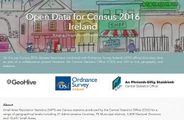
Ordnance Survey Ireland (OSi) and the Central Statistics Office (CSO) have launched a new website available here ...
By Oscar Michel, Masters in Journalism, DCU.
14-16th July, the Longitude festival took place in Dublin. Esri Ireland, the market leader in Geographic Information Systems (GIS), and An Garda Síochána has leveraged its ArcGIS platform to create an ...
By @SimonCocking
Describe the PROJECT – the elevator pitch ...
INFOMAR is a joint venture between the Geological Survey of Ireland (GSI) and the Marine In...